


lisvarrinane new

mlmoroneybb
Gebruiker

Lengte
4,6 km

Max. hoogte
190 m

Positief hoogteverschil
102 m
Km-Effort
6 km

Min. hoogte
101 m

Negatief hoogteverschil
101 m
Boucle
Ja
Datum van aanmaak :
2014-12-10 00:00:00.0
Laatste wijziging :
2014-12-10 00:00:00.0
1h17
Moeilijkheid : Gemakkelijk

Gratisgps-wandelapplicatie
 SityTrail
IGN / Geografische instituten
SityTrail Plus
De wereld gaat voor u open
Over ons
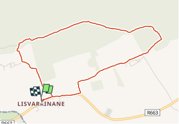
Tocht Stappen van 4,6 km beschikbaar op Onbekend, County Tipperary, The Municipal District of Cahir — Cashel. Deze tocht wordt voorgesteld door mlmoroneybb.
Beschrijving
Walk
Plaatsbepaling
Land:
Ireland
Regio :
Onbekend
Departement/Provincie :
County Tipperary
Gemeente :
The Municipal District of Cahir — Cashel
Locatie:
Clonbeg
Vertrek:(Dec)
Vertrek:(UTM)
552557 ; 5807142 (29U) N.
Opmerkingen